Worli Fort, Mahim Fort and Bandra Fort - guarding Mahim Bay
After visiting Sewri Fort on the east coast and Sion Fort to the north or the erstwhile Bombay Island, I wanted to visit the other three forts on the west coast. Worli Fort and Mahim Fort were on the British controlled Bombay Island while the third – Bandra Fort – was on the erstwhile Salsette Island controlled by the Portuguese.
Worli (originally Wadali – or the village of the wad i.e. the Banyan tree) was a separate island, with the fort on one end of a rocky ridge that began from Malabar Hill. Worli island was separated from the Mahim island by a branch of the sea. The book “A Handbook for India Part II – Bombay”, by John Murray contains this interesting passage:
Freyer, in 1680, speaks of Mahim as a separate island. He says, “in the middle, between Parell and Mayem (Mahim), Saeem (Sion) and Bombaim, is a hollow, wherein is received a branch of the sea, running out at three several places, which drowns 40,000 acres of good land; athwart which from Parell to Mayem, are the ruins of a stone causeway made by Pennances.” The places where the sea entered are between Riva Fort and Mahim; between Worli and Mahim Woods; and between Breach Candy and Lovegrove
") Later, the sea apparently receded between Worli and Mahim or was reclaimed, and the islands were joined together. The above reconstructed 17-18th century map shows the joined islands with the locations of the forts. The gap between Mahim and Salsette was later breached by a causeway between Bandra and Mahim funded by the philanthropic Lady Jamshetjee Jeejeebhoy
Later, the sea apparently receded between Worli and Mahim or was reclaimed, and the islands were joined together. The above reconstructed 17-18th century map shows the joined islands with the locations of the forts. The gap between Mahim and Salsette was later breached by a causeway between Bandra and Mahim funded by the philanthropic Lady Jamshetjee Jeejeebhoy
The three forts are on three corners of the Mahim Bay. At the southern end is Worli Fort, Mahim at the corner of Mahim Causeway, and Bandra Fort at Land’s end
 I started from the south from Worli Fort. After cycling to Worli Sea face to enjoy the early morning sea breeze, I took the detour inside the fishing village and went through narrow lanes and cute houses to reach the fort at the end
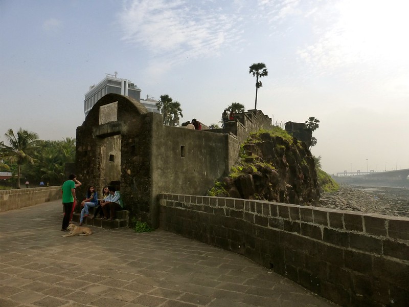
 The fort was almost completely restored by the Archeological Society of India in 2008-09 and is now quite well maintained. You can enter the fort using the steps that lead to an arched gateway.
 The arched gateway leads into this small tunnel that leads to the interior of the fort
 As you enter through the tunnel-like entrance, you see the cute little fairy tale like fort’s interior which is split into two levels. A central courtyard is at the level of the entrance, and along the ramparts is a broad corridor at a higher level that offers a great view of the Mahim Bay on the south and the Worli sea face on the north
 Almost half of the courtyard has been occupied by an unauthorized structure with an asbestos roof, which houses a gymnasium for the locals to use. Though this may not be really legal, I do not think it’s too bad an idea – at least the place is kept clean and tidy
 In the remaining area of the courtyard, there is a small temple and a sort of garden patch to the right, and the stairs to climb to the higher level to the left
 I was hoping to see some sculptured deity inside the temple but there was only a framed photograph on a pedestal. So either this is a new construction, or the idol is missing
 The garden patch next to the temple is painstakingly decorated with patterns made from white sea shells. Someone is surely taking care of this place
 The panoramic view from the fort is breathtaking. You can see the entire Mahim Bay to the south, and the sea link snaking its way across the bay towards Bandra
 Here is a larger view of the sea link, which seems to go to infinity, into the clouds beginning to shine with the rays of the rising sun
 Then I see the sun peeping through the thick monsoon clouds as its rays form a halo around them
 After taking several photographs of the rising sun and the beautiful light it cast everywhere, I exited the fort and walked around the fort through the fishing village
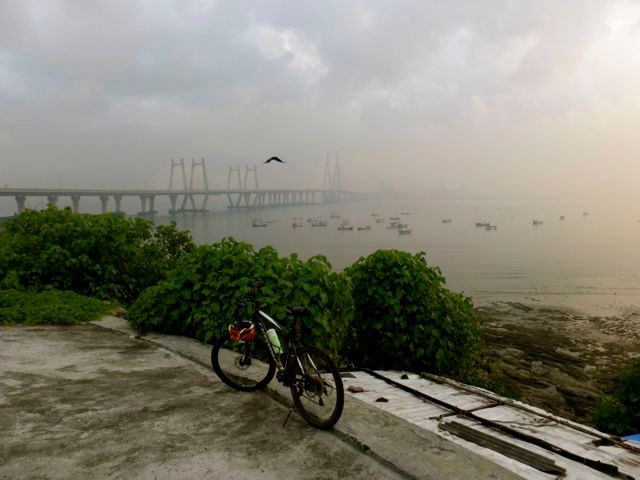
 I paused for a while at the tip of the village to get another view of the sea link and the boats lazing around in the bay
My next destination is Mahim Fort, accessible from the open area along Mahim causeway between the Western Express Highway Junction and Mahim Church. Some background about the church:
Strategically located in the Mahim Bay, the fort overlooks Worli to the south, Bandra to the north, and Mahim to the east. The origins of the fort are unclear, but it occupies a strategic location that has been frequently contested. The fort is currently in disrepair, suffering from administrative neglect, encroachment of slums, and exposure to tidal erosion.
In 1516, Portuguese commander Dom Joao de Monoy entered the Mahim Creek and defeated the commander of Mahim fort. The fort was the site of frequent skirmishes between the Portuguese and the Ali Shah, a Gujarati ruler, before the island of Mahim was appropriated from Bahadur Shah of Gujarat by the Portuguese in 1534. In 1661, the Portuguese ceded the island of Mahim as dowry to Charles II of England. After the English gained control of the fort, it was strengthened by Sir Thomas Grantham in 1684 and became a strategic watchtower against possible Portuguese attacks, and later from the Marathas.
In 1772, the Portuguese attempted to attack this fort, but they were repelled by the British with cannonballs.[2] The Mount Mary’s Basilica was damaged during this encounter. According to historical accounts, the fort had 100 soldiers and 30 cannons at that time
 To access the fort, you have to walk through the scores of bamboo stacks that are laid out on the southern end of the open space
 The fort itself has been completely occupied by shanties and is in a horribly dirty state. The entrance is completely blocked and my attempt to enter was thwarted by the locals dissuading me
 The only way to see the fort is from the sea. At low tide, you can walk around the fort. There is no real beach. There is a rocky patch around the fort, and it is extremely dirty so do not be surprised if you have to make your way around people who are busy with their morning biological rituals
 The north end of the fort has a long wall that is largely intact, with an arched entrance that is now completely blocked
 A panoramic view of the fort from the sea gives a clear idea of its size. It is actually quite a large fort and could have been truly a fabulous site if maintained well
 At one place, between broken walls, there is an exposed cavity from where one can see an arch up on top of the ramparts. This could possibly have been a jetty of sorts
 Looking out towards the sea from within this cavity, one can get a hazy view of the sea link out into the bay
Next destination, Bandra Fort or Castella de Aguada located at Land’s End in Bandra. To get there, I had to ride via Mount Mary’s Church and it was a Sunday and time of the festival. So I waded through throngs of devotees arriving in all kinds of vehicles, but quite peacefully and in an orderly fashion.
“Castella” is a misspelling for Portuguese “Castelo” (castle). Properly, it should be called Castelo da Aguada, although it seems its Portuguese builders actually called it Forte de Bandorá (or Bandra Fort). It is located at Land’s End in Bandra. It was built by the Portuguese in 1640 as a watchtower overlooking Mahim Bay, the Arabian Sea and the southern island of Mahim. The strategic value of the fort was enhanced in 1661 after the Portuguese ceded the seven islands of Bombay that lay to the immediate south of Bandra to the English. The name indicates its origin as a place where fresh water was available in the form of a fountain (“Aguada”) for Portuguese ships cruising the coasts in the initial period of Portuguese presence. The fort lies over several levels, from sea level to an altitude of 24 meters (79 ft)
The Portuguese, who had established a base in the area in 1534 after defeating Bahadur Shah of Gujarat, built several sea forts along the western Indian coastline. Castella de Aguada was one such strategically located fort, overlooking the Mahim Bay to the south, the Arabian Sea to the west, the islands of Worli to the south and the town of Mahim to the southwest. The fort also guarded the northern sea route into Mumbai Harbour. This sea route, a large estuary, was later reclaimed from the sea in the nineteenth century. During the Portuguese rule, it was armed with seven cannons and other smaller guns as a defence. A freshwater spring in the vicinity supplied potable water to passing ships, thus lending the fort its name.
After the decline of the Portuguese in the early 18th century, the Marathas became the largest threat to British possessions. Sensing an impending Portuguese defeat, the British partially demolished the fort as a precautionary measure. The demolition would obviate the possibility of the fort being captured by the Marathas, with the possibility of it being used as a forward military base to attack British Bombay.
In 1739 the island was invaded by the Marathas; it was ruled by them until 1774 when the British gained possession of the area during the First Anglo-Maratha War. In 1830, the British donated large parts of Salsette Island, including Land’s End, to Byramjee Jeejeebhoy, a Parsi philanthropist. Jeejeeboy then established his residence on the hill where the fort is located, and the cape was renamed Byramjee Jeejeebhoy Point
 Castella de Aguaga – The Last Bastion. 1517 saw the commandment of the Mahim Fort fall to the might of the Portuguese as they set foot in ‘Bandora’ (Bandra). 1640 saw the rise of the ‘Castella’ or bastion. The Portuguese built this strategically located fort as an outpost marking the southernmost tip of the mainland. Fresh water springs located close to the fort served as a potable water point when they sailed across. They exist to this day, but now serve an entirely different people – the local washermen! Though the Castella is almost entirely destroyed, the ruins remain one of the few standing reminders of the days of Portuguese glory.
 In 2003, a conservation program was started by Bandra Band Stand Residents’ Trust to save the fort. It was spearheaded by a local Member of Parliament (MP), Shabana Azmi, who funded part of the effort from her allotted funds. This arched entrance was earlier in a dilapidated condition but is now restored
 From the open courtyard, the view of the sea link and the calm waters of the Mahim bay is magical – could sit here staring into the sea for hours
 Looking back from the courtyard, you can see the fort snake up the hill, with Taj Land’s End hotel peeing from behind
 Through the second arched gate, there are steps that take you up the hill into the fort
 As you climb up the hill, you start seeing why this fort was so strategic in its location. The view of the sea and the bay is so clear, there could have been no chance of any unwanted visitors coming in from the sea without being noticed
 This sign on the ramparts of the fort juxtapose well with the view of the “End” of the seal link at Bandra
 At the top of the hill, there is now a beautifully maintained garden with lots of trees and grass, and a winding path throughout. An ideal place for young couples to spend some quality time together :)
 Another quite redundant sign on the wall recommends those inspired to take a better look as opposed to taking any action detrimental to their life
 This expedition could not be considered complete till you see a panoramic view of the sea link at the other end. It was a beautiful way to study the historical forts around Mahim Bay, contrasted by the symbol of modern India – the sea link
 One last look at the fort and the sea link before heading back home, satisfied by a morning’s exploration of three forts and the Mahim Bay
These three forts, combined with Sion Fort, Riwa fort and ending in Sewri Fort can form a nice cycling route of just about 25 kilometers, and can cover the entire list of coastal forts of the erstwhile Bombay Island.