Trek to Asherigad - protector of the Palghar region
Palghar is a beautiful coastal town that is nestled between the sea to the west and the mountains to the east. The Palghar region in Thane district the maximum number of forts as compared with other regions in the district. Some of these are sea forts located along the coast such as Paankot or Alibaug Fort, Kelve Fort, Bhavangad Fort, Mahim Fort, Shirgaon Fort and Tarpur Fort. While other forts are on the top of the hills that lie to the east of Palghar – such as Tandulwadi, Kaldurg, Asava, Asherigad and Adsul.
We had covered most of the sea forts in Palghar in a previous expedition, but the hill forts were yet to be explored. This weekend, I joined a group of trekkers to cover two of these hill forts – Asherigad and Kaldurg.
| Detail | Description |
|---|---|
| Grade | Medium to hard – some steep slopes but has a ladder on the steepest section |
| Height | 1600 – 1800 feet |
| Range | Palghar (District Thane) |
| Base Village | Khadkawane Thanks to Tarun Darolia for the initial research, directions and statistics of the fort |
Asherigad is just left of NH8 highway. If you are driving, look out for an Indian Oil Petrol Pump, and about a kilometer after that is the turn-off. If you take a bus ask for Khodkona village bus stop
 The turn-off from the highway towards Asherigad is easy to miss. State Transport buses stop here – ask for Khodkona stop. There is a small cabin and a dirt trail leading off to the Khodkona village. The village is about a kilometer away from the highway.
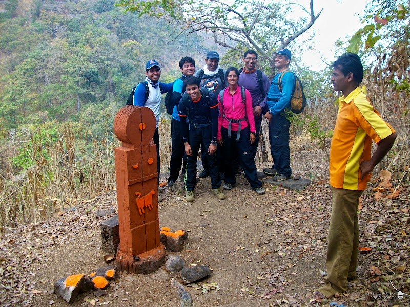
 We parked in an open field adjoining the village, with the fort in the background. One of the villagers – Lakshman (telephone: 07875466673) – offered to act as a guide to take us up to the fort. He turned out to be an excellent guide and meticulously showed us each of the artifacts in the fort.
The trekking route starts from Khodkona and winds through the forest to reach Khadkawane and further straight ahead to climb the ridge to the north of the mountain. Then we climb up the rocky face and come to the crevice on the west face of the fort. On the top, we took an anti-clockwise route around the fort, and ended back at the same point to return
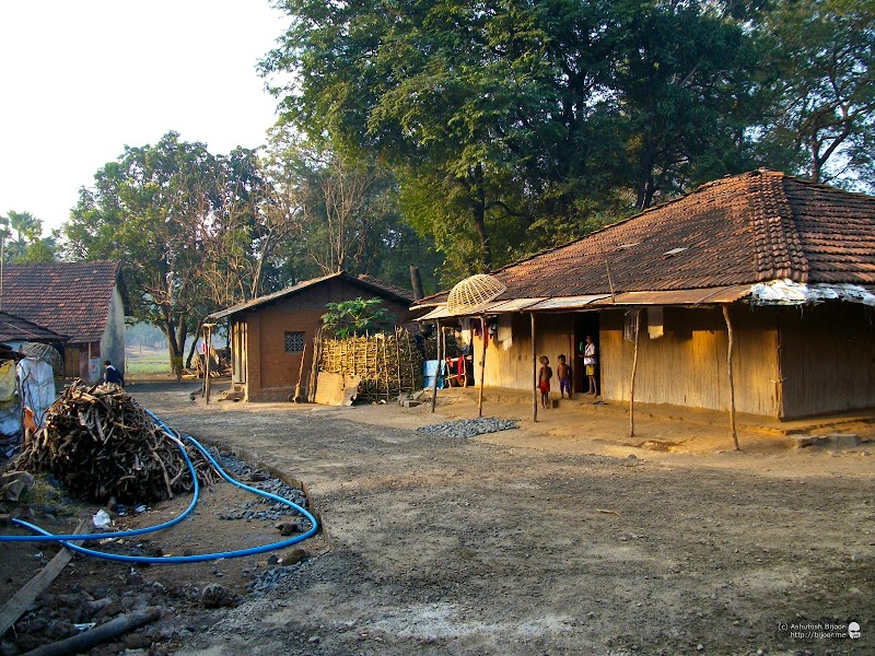 We walked through the Khodkona village where the residents were going about their morning chores with smoke trickling out of their homes. The newly laid concrete road was still under construction.
 After we passed the village, the path leads up on the right through the forest, climbing rapidly uphill through between teak trees and rocks. There are white arrows drawn on rocks at regular intervals in case you do not have a guide to show the way
 As you emerge from the forest onto a small ridge at the north of the mountain, you turn right and start climbing up on to the peak over the bare rocky section without tree cover.
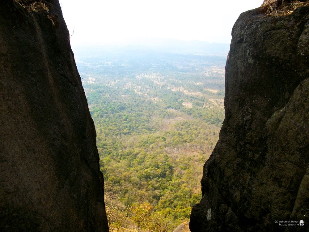
 While you climb the hill, a beautiful vista opens up to the north, with the fog covered valley through which the highway NH8 snakes its way towards Ahmedabad.
 Half way uphill, a small clearing beside the track has this wooden deity of Waghoba. Waghoba is recognized as a forest god by villagers and there is a special function in the month of Chaitra (March-April) when hens and goats are sacrificed to this tiger deity. Waghoba is worshipped so as to ensure that tigers cause no harm to the people and farm animals (ref)
 The last section is a climb over a rocky patch, with steps cut into the rock face. At the bottom of the steps is a small tunnel that is presumably for water harvesting and is supposed to lead to a water tank
 At the top of the rock face is a flat landing area, where a hole in the ground probably for a flag post can be found. Looking down one can see the dense forests covering the surrounding hillsides. The Kolis – early settlers in this area used the teak from this forest for building houses and boats and was also exported by sea. (ref)
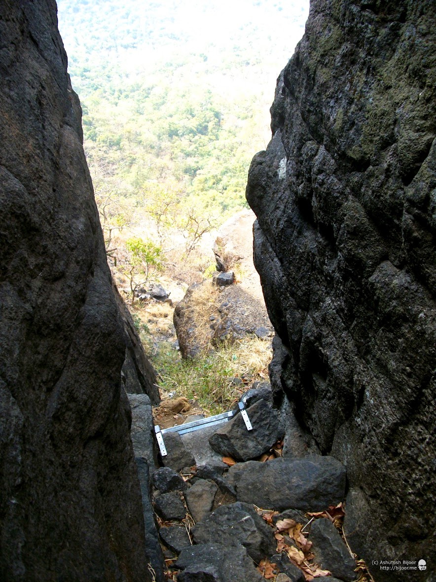
 From this landing, a small distance ahead is the crevice that leads up to the fort. A steel ladder has been kept here to assist visitors to climb this tricky section.
 At the top of the ladder there are steps cut into the rocks that lead up to the top.

 Immediately after you enter the fort, this impressive rock sculpture of a crown and shield greets you. This fort was first built by Raja Bhoj presumably in the 13th century. Later Bhimdev (also called Bimba) took it over in the 14th century. The Portuguese captured the fort in 1556 as part of their occupation of the Vasai area. This crown and shield must be from that era. The fort was later taken over by Chimaji Appa in the battle of Vasai on 17th January 1739 (ref)
 A short climb away is the fort’s main entrance gate that is now quite ruined. During the time this fort was used, there were over 700 people staying here, with facilities such as houses, a school, a prayer hall, and ample water supply was provided (ref)
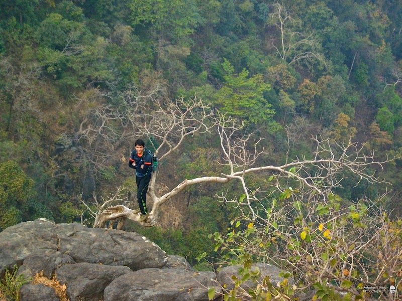 A tree that grows outward from the edge of the mountain provides a great photo opportunity.. and Ankit, the youngest of the group is quick to strike a pose on it
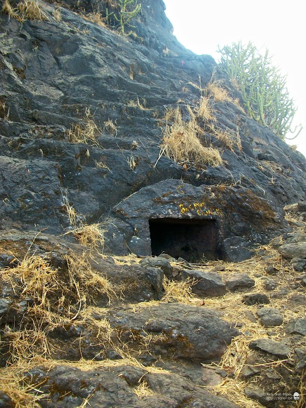
 There are several water tanks spread across the area of the fort. One such water tank is like a cave. There was no water in it now, but during the monsoon it surely would have sufficient water
 Some of us climbed into the tank to take a closer look at these patterns created on the ground presumably by insects walking over the wet mossy floor. But it sure looked like some extraterrestrial landscape!
 Next we visited a group of water tanks that are located on the southern edge of the mountain so that they can collect water that flows down the sides. Though the water in most of the tanks is not potable, a few tanks are quite clean and Lakshman, our guide confirmed that the water can be used for drinking
 The view of the plains to the south east with the hills of Jawhar. In the Portuguese era, there were three different kingdoms that bordered Asherigad – to the north-east was the kingdom of Chandahar – presumably part of the Mughals, to the south-east was the empire of the king of Ahmednagar and in the forests nearby to the east were the Kolis ruled over by King Bhimdev. This made Asherigad very strategic for the Portuguese occupation (ref)
 The mountain top is like an arrow head, pointing towards the north-west. To the south, there are two tips – one facing east and one facing south, with a large crevice between them. This view is of the east facing tip, from where we headed to the northern face of the mountain
 As we walked slightly inward, we came across this structure that looks like the remains of the foundation of some buildings that could have been the residential houses or school that were part of the fort
 Next we visited this Maruti (Hanuman) temple located in a shallow cave towards the north face of the mountain, with an old cannon lying in front.
 Inside the cave is this rough idol of Lord Hanuman – also called Maruti – the monkey god who is the son of Lord Vayu – the god of the wind. What better place to worship this god than this place high in the mountains!
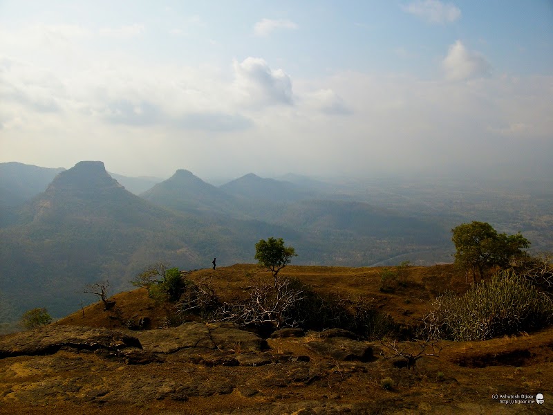 The next short halt is to admire the view to the north. The mountain straight ahead has the three peaks, and to the right of it is the actual Asheri village that gave the name to this fort. The figure in the foreground at the edge is Sameer, who wandered away from the group to admire the view
 As you walk away from the north face inwards towards the center of the fort, there are two large water tanks – or artificial lakes. This one has a stone structure at the far end that has placeholders for idols, very similar to what I had seen at Harishchandragad
 Our group of trekkers take meditative positions for a photograph – but their excitement is far from a meditative state of mind, and as soon as the photo was done, they were up and ready to move to the next stop
 The second artificial lake is easily the highlight of this trek – for it is full of lotuses with a striking pink colored blossoms
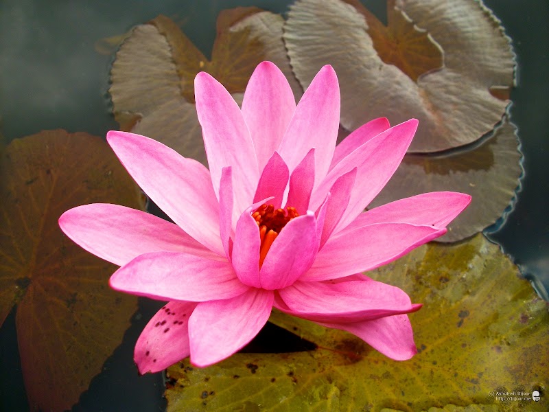 A closer look at one of the blossomed lotuses reveals the beauty of the flower and it’s riotous pink color. The lotus flower represents one symbol of fortune in Buddhism. It grows in muddy water, and it is this environment that gives forth the flower’s first and most literal meaning: rising and blooming above the murk to achieve enlightenment. The pink lotus flower represents the history of Buddha and the historical legends of the Buddha. (ref)
 We then walked southward towards a thickly wooded area in the center of the mountain-top, where there are ruins of several buildings. This was probably the center of all the human activity in the fort, though now it is overgrown with vegetation
 This set of stone pieces with their curved faces look like the remains of an arched doorway, and Lakshman confirmed that indeed they were
 Finally we came back to the fort entrance, looking down towards the crevice from where we climbed up into the fort.
 Then the climb down the steep crevice with the steel ladder, and we’re back on the path leading back to Khadkawane
 The climb down took us much less time, and we were back in Khodkona in about an hour. The village was still sleepy and inactive, and we quickly made our way to the vehicle and feasted on the yummy packed food – theplas and extremely spicy thecha!
 We were all keen to do another trek, for we still had the afternoon ahead before we return to the city. After much debate, we decided to visit Kaldurg, which is on the way to Palghar from the NH8 highway
This post will become too long and time-consuming if I try to combine both the treks. So am creating a follow-up post on Kaldurg… coming soon!