Goecha La Trek - experiencing Sikkim at its best
There is no better way to experience Sikkim than to do one of the high altitude treks in it’s mountains. The most well known trekking route in Sikkim is the Khangzenchenzonga (Kanchenjunga) Trekking Trail that leads from Yuksom to the Goecha La pass. Starting at the highest motorable road in Sikkim at Yuksom, a quaint little town at an altitude of 5670 feet above mean sea level, ending at Goecha La pass at 16,207 feet above mean sea level. With a total altitude gain of over 10,000 feet, this trek is not for the faint hearted. But it is a trek that anyone can do with a little bit of determination and patience!
 The trekking route starts from Yuksom – and more specifically from the Trekkers Hut in Yuksom. Day 1 trek goes up to Sachen. Day 2 up to Tshoka, day 3 to Dzongri, day 4 to Thansing, day 5 to Lamunay, day6 takes us to the final destination at Goecha La pass and back to Lamunay for lunch to continue down to Kokchurung, day 7 to Tshoka and day 8 back to Yuksom
 We had arrived at Yuksom after a flight from Mumbai to Kolkata and an overnight train journey from Kolkata to New Jalpaiguri (NJP). With only one reserved seat among 5 of us, I had the honor of sleeping in the caretaker’s cupboard that is normally reserved for all the blankets and bedsheets, while some others slept on the floor in the aisles. Then a bumpy jeep ride lasting over 6 hours took us from NJP to Yuksom
 At Yuksom, we were put up by India Hikes at this home stay very near the Trekkers Hut. We all bundled up in small rooms at multiple levels and had our first dinner together as a group. There were trekkers from all over – Mumbai, Pune, Bangalore, Hyderabad, Jamshedpur, and even one young man from England
 The next morning, after a healthy breakfast we all gathered together in an open field for our briefing. The trek leaders – Anas, Kamal and Parth told us about the trek route, taught us breathing techniques to overcome the high altitude and low atmospheric pressure as well as the cold, and taught us stretching exercizes that would keep our muscles ready for the long hours of trekking ahead
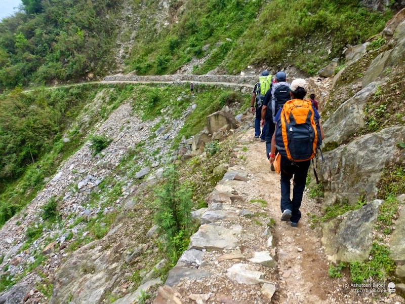 We then started the trek from the base camp at Yuksom to our first camp site at Sachen. The route is fairly easy with gradual climbs and descents that takes us along the mountain sides of the Prek Chu river valley

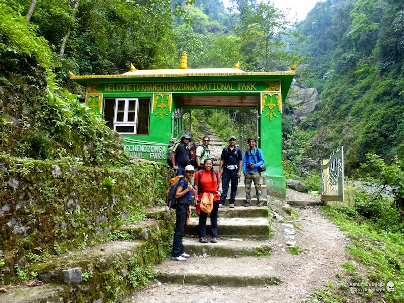 We cross the Prek Chu river over this suspension bridge, and enter the Kanchendzonga National Park. India Hikes has already arranged for our permits to enter the park, but otherwise you would need to get these passes at Yuksom. There is a small arched gateway that marks the entrance to the national park, from where there is a great view of the river flowing beside it into the valley below
 We come across the first of the Yak herd carrying all the supplies for a trekking group. It is important to step aside and let the Yaks pass as they slowly but gracefully make their way on the treacherous route with ease
 We reach Sachen camp site in just over 2 hours – but it was well over 4 hours till the camp was setup and the stragglers caught up. Sachen is at an altitude of 7150 feet – so we had already climbed over 1100 feet today
 Once the mules and yaks arrived, our guide Bir and his group of sherpas quickly setup our tents. These were 3-person tents and our group of 28 trekkers required 10 tents in all. Meanwhile I and Shimul made hangers out of twigs and hung our T-shirts out to dry in the sun.
 But later that evening it started raining heavily, and the entire camp site was converted into slushy mud, and some tents had water seeping through. Plus, there were small insects that buzzed around and bit any exposed parts – leaving itchy marks that remained as souvenirs beyond the trek. This was not the best start for the trek.
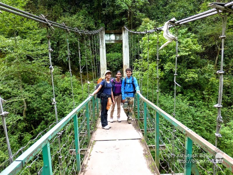 The next morning was however glorious as the sun had come out and the rain had spent itself through the night. We gladly proceeded ahead from Sachen to the next camp at Tshoka. We made a sharp descent to cross the river on another suspension bridge, and then trudged uphill 1200 feet to reach Bakhim at an altitude of 8600 feet
 A small outhouse at a local home in Bakhim makes an ideal resting point, where we took a short halt to have our packed lunch and some hot tea.
 There is also a forest guest house at Bakhim that overlooks the fabulous view of the valley below. A board at the guesthouse claims an altitude of 9000 feet
 The view from the guest house is of the valley below with the Prek Chu river flowing, and Yuksom somewhere far into the distance. But we still have a further climb ahead to Tshoka.
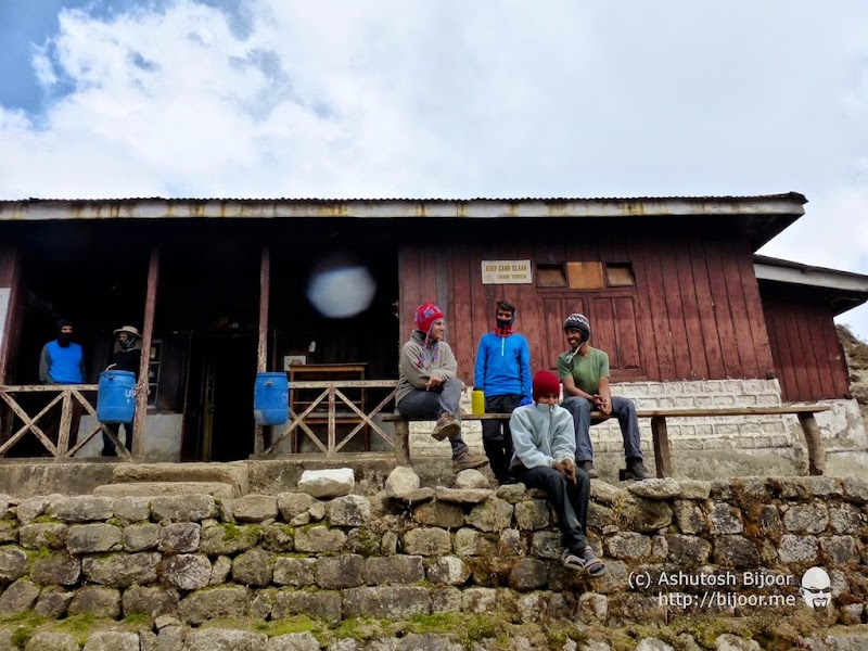
 We arrived at Tshoka – at an altitude of 9700 feet. Tshoka is an idyllic village consisting of 3-4 houses that are occupied for half the year and abandoned during the winter months. There are several log huts built for trekkers here, with bathrooms outside. A water pipe runs from a mountain stream and passes through each house, providing a constant supply of fresh water
 At the top end of Tshoka is a small pond with a monastery next to it, which was locked up
 We explored the entire settlement, admiring the small wooden houses with smoke from the cooking fires spiraling out of the roofs
 The mules and yaks grazed idly in the open meadows, while birds of all kinds were chirping in the trees

 Back at the camp, Pavan brought out his frisbee and taught everyone the techniques of handling the disc…

 …and soon we all got addicted to the sport and it became our standard pastime at all camps thereafter
 The next morning, we woke up to our first view of the snowcapped mountains. At the leftmost is mount Pandim with Thansing and other equally impressive peaks to the right
 After breakfast, we all packed up and got ready for the next stretch from Tshoka to Dzongri, which was considered to be one of the toughest stretches with a climb up from 9700 feet to 13000 feet, and then down to 12980 feet to camp at Dzongri
 As promised, the trail immediately started climbing up the mountain from Tshoka and we could see the camp site, the lake and monastery below us while we rapidly gained altitude
 As we approached the midway point at Phedang (12000 feet), the path was lined with wooden slats in the ground, preventing our feet from getting stuck in the sticky mud underneath
 Though we struggled to climb the tough gradient, the beauty of the forest kept us enthralled and we began enjoying the climb
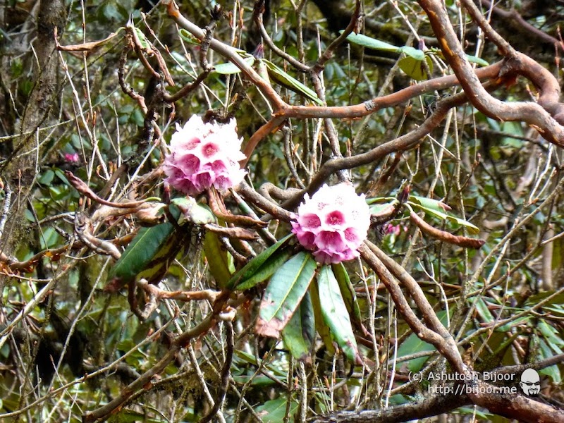
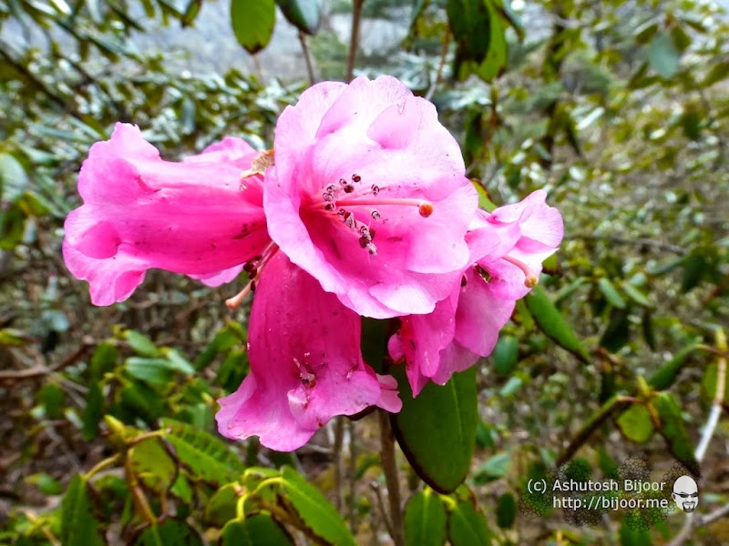
 On either sides of the path, rhododendrons bloomed in all colors
 After a short halt at Phedang (12000 feet), the climb continued till we reached the highest point at 13000 feet, and then climbed down to Dzongri at 12980 feet
 The last stretch was an easy downward path through rhododendron bushes and the view of snow capped mountains and clouds ahead. We increased our pace, eager to reach Dzongri camp
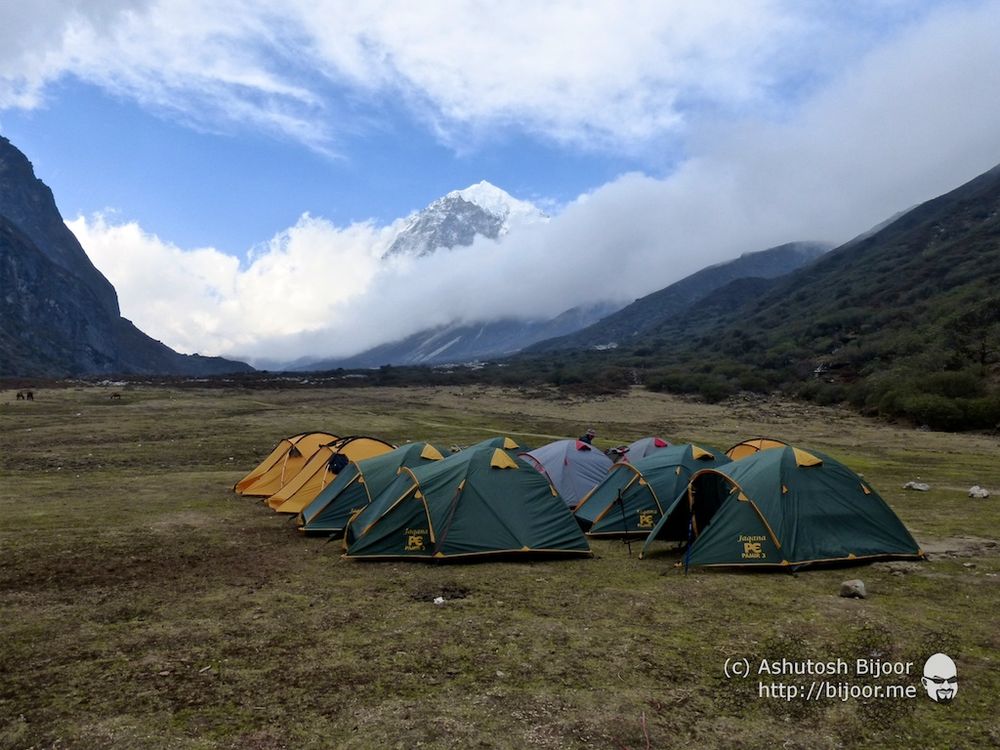
 The camp site at Dzongri also has a log hut with rooms, though India Hikes only used it for its kitchen and dining room. The temperature was significantly colder now, and we had to pull out our fleece jackets and woolen caps. Soon a passing cloud showered some hail stones down on to us
 Later we climbed up the hill next to the camp site, looking down on the camp site and the path leading up to it
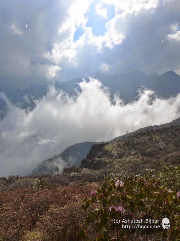
 We were regaled by a magnificent ballet put up by the clouds and the sun in this wide arena of the mountains


 Next morning we started early at 3 am and climbed in the dark to Dzongri top at 13675 feet, just in time to catch the sun rise. The 360 degree view from Dzongri top is one of the best views of this trek
 On the left, the far away himalayan peaks of Nepal, while on the right hidden partially by the black peak of Black Kabur is the mighty Kanchendzonga (Kanchenjunga) and to the extreme right is mount Pandim
 As the sun rose in the sky, it lit up the clouds and the mountains with fiery colors
 The mountains looked glorious in the emerging sunlight, and we soaked in the views around us before heading back down to the camp
 A group photo of the entire trekking team… we also celebrated Mohit’s (extreme left) birthday – what a special place to have his birthday
 Back at the camp we packed our backpacks and set off to our next destination – Thansing – at a height of 12900 feet, via Kokchurang (12000 feet)
 The initial section is an easy walk through meadows with the view of the snow capped mountains hiding behind the clouds up ahead
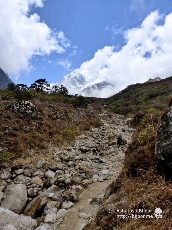
 Then we reach the highest point from where we can see the Prek Chu river down below, beside which is the camp of Kokchurang. The steep climb down was tough on the knees after which we had to climb back up on the other side of the river towards Thansing
 We reached the Prek Chu river and Kokchurang after the steep climb down and took a brief rest to admire the river and refill out water bottles, and then made our way to the last section to climb up to Thansing
 The climb took us through forests that were full of thick moss covered trees that looked straight out of a Tarzan movie, while the last section of the climb was along a stream that is a tributary of the Prek Chu river we left behind with the view of mount Pandim ahead keeping us going till we reached the camp site
 The camp site at Thansing (12900 feet) is cradled between two mountains on either side, with mount Pandim visible straight ahead. The valley created a conduit through which cold winds blew hard, making the cold bite through our warm clothing
 Luckily by evening, the winds had subdued and the clouds cleared up. It was now comfortable enough and we walked around to explore the area around the camp site and others started the signature game of frisbee
 In the evening we huddled around in the dining room waiting for the hot soup followed by freshly cooked food – only to dread the thought of having to wash our cups and dishes in the ice cold water outside
 We woke up next morning to find a clear crisp mountain air and took our hot cups of tea to a sunny spot to enjoy the view in the welcome warmth of the sunlight
 We also met with Sanman who runs a small kitchen at the camp site and who engaged us with stories of how he saw a large footprint presumably of the Yeti on one of his sojourns from Yuksam
 The next section of the trek is the shortest and easiest section that takes us from Thansing (12900 feet) to Lamuney (13600 feet) a short walk of about an hour and a half through the valley
 Lamunay is our last camp site. We trek from here to Goecha La the next day and back – our longest and most exciting day – so we relax at the camp to recoup our energy and prepare for the climax
 With no permanent structure for a dining place, India Hikes puts up a dining tent which is actually too small for all 28 of us. But we huddled together in it to keep ourselves warm and pretty much filled the entire tent with warm bodies
 After tea, the entire huddle moved to a small stone shelter next to the camp, and we chatted and joked around trying to keep warm. Lots of laughter and fun – we had a great crowd!
 Small streams flowed from the hills down to the river next to our camp site and though it was ice cold, we enjoyed drinking the cold fresh water
 We had an early dinner and went to bed at 7 pm, to wake up at 2:30 am next morning and set out to reach view point 1 just in time to catch the sun rise
 We were not disappointed – soon the early rays of the sun lit up the clouds behind the mountains, making them appear like volcanoes emerging out of the snow capped peaks
 The view just got better as the sun rose further in the sky. By this time, most of our trekking group had arrived at the first view point and everyone enjoyed the fabulous view
 Then it was time to move ahead to view point 2, our final destination next to Goecha La pass at 16200 feet. This last trek was the most difficult section – the air was quite rare and it was biting cold. We had to breathe deep and fast. We initially covered the flat ground left behind by the avalanche and then climbed up to the pass
 Then the path climbed higher and higher, making it more and more difficult. We slowed to a step a second with one breath per step, climbing slowly but steadily up to the last point
 And what a feeling it was to reach the final point! We had climbed from 5600 feet at Yuksom to 16200 feet in 6 days and this was the final destination!
 The view was just completely unreal. With the Goecha lake down below us, and mount Pandim behind us, we could see a glimpse of the mighty Kanchendzonga (Kanchenjunga) up ahead of us
 We were exhausted but thrilled at having completed the trek successfully – missing our son Rohan who could not make it, but this was the high point of the trek and we made the most of the moment by soaking in the view and the cool mountain air
 Not everyone who attempted the trek was as lucky as us, as this epitaph proved. Luckily none of us had any health issues and no signs of acute mountain sickness either
 Then it was time to head back down the treacherous path towards our camp at Lamunay. We slowly made our way down, taking it easy after having successfully climbed up to our destination
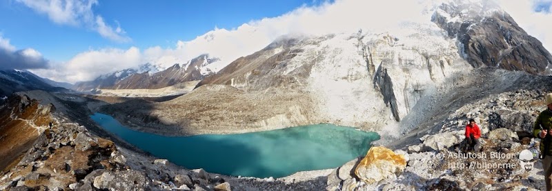
 On the way back we spotted Samiti lake at 14100 feet, where we took a break to rest and admire the last few moments at this ethereal place
 Samiti lake has crystal clear turquoise colored water with a small path that goes all around. We lay around along the lake shore, resting till the other trekkers made their way down.
 Now no more in a hurry to get the the top, we started noticing the beautiful flora and fauna of the mountains. This bright beautiful blue bird is the very rare Grandala male (ref) Thanks Yogish, for pointing this out in the comments!
 And this grey bird is the Grandala female. Again thanks to Yogish for the info!
 After a lunch break at our camp at Lamunay, we head out to trek to Kokchurang next to the Prek Chu river that we had passed on our way up.
 The camp at Kokchurang (12000 feet) is one of the most beautiful camp sites of this trek. Just next to the Prek Chu river, this camp has a proper log cabin and toilet block, and for the first time we actually had enough place to put our sleeping bags in the log hut and sleep. We slept well after over 12 hours of trekking the previous day.
 We woke up to another glorious morning all set to head back to Tshoka – this time skipping Dzongri altogether and circling around directly to Tshoka via Phedang
 We followed a path that took us deep into the rain forest full of chirping birds and a rich biodiversity of plants
 We took a short break at Phedang that was covered in a thick fog, and where our yaks overtook us
 Back at Tshoka, we set up camp and relaxed for the rest of the day, some playing frisbee, others exploring the meadows chasing birds, while some others playing cards in the log hut
 The magnificent Yellow-billed Blue Magpie visited our camp site to pick up bits of food around the kitchen while the mules lazily grazed behind the camp in the mountains

 Next morning – our last day of the trek, we posed for one last group picture of the entire trekking group, and headed down the long trek to Yuksom, a descent from 9700 feet to 5670 feet over 14 kilometers
 Back at Yuksom, we celebrated the completion of our trek with a hot (ok not cold) water bath, wore fresh clothes and headed to a nearby hotel (ok kitchen) where we drank Chang
 Chang is a local drink made from fermented millet in a bamboo pitcher with a bamboo straw – in which one poured hot water repeatedly till the flavor died down – a perfect drink to accompany long conversations reminiscing about the exciting moments of the trek
 We had one buffer day that we did not use, and we spent this day walking around Yuksom
 We visited the monastery in Yuksom where we admired the intricate artwork of the deity within,
 and the colorful flowers in the garden outside
 We stopped by at Kathok lake – a serene and peaceful place to sit around and read a book. The charm of Yuksom was addicting, and we felt like we should have spent a few more days here
 Yuksom was the first capital of Sikkim established in 1642 AD by Phuntsog Namgyal who was the first Chogyal (temporal and religious king) of Sikkim. The coronation site of the first monarch of Sikkim is known as the “Throne of Norbugang”. In 1642, three lamas from Tibet went in search of the chosen person in the eastern region. Near the present day Gangtok, they found a man churning milk. He offered them some refreshments and gave them shelter. So impressed were they by his deeds that they realised that he was a chosen one. They also identified Phunstsog Namgyal’s ancestral royal links with Tibet and decided that he was the right person to become the temporal and religious head of the region, and then they brought him to Yuksom. They then crowned him at Norbugang near Yuksom as the temporal and religious king of Sikkim, with the title of “Chogyal”. The crowning took place at Norbugang on a pedestal set in stones, in a pine-covered hill, and he was anointed by sprinkling water from a sacred urn (ref)
 We spent the last few hours in the organic garden behind Limboo Homestay where we had shifted for the last night
 The clean beds and warm blankets were perfect for a rest day to recuperate from the arduous trek, and the yummy food made with produce from their organic garden was the best antidote for the oily food on the trek
 This was one of the most exciting adventures we had as a family, and we vowed to come back again and enjoy another adventure in Sikkim soon