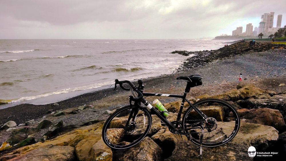
Mumbai Coastal Ride - a cycling tour of the seven island city!
On the map, Mumbai now looks like it is part of the mainland. However, it was originally an archipelago of several islands that were joined together by reclaiming the gaps between.
The southern part of Mumbai, originally called Bombay was separated from the northern island of Salsette (Shashti) by the Mahim river, and was formed by combining seven different islands, referred to by Ptolemy in 150 AD as Heptanesia (ref):

- Colaba: whose name is a corruption of the Koli name Kolbhat.
- Old Woman's Island: (alternatively, Old Man's Island) a small rock between Colaba and Bombay, whose name is a corruption of the Arabic name Al-Omani, after the deep-sea fishermen who ranged up to the Gulf of Oman.
- Bombay: the main harbour and the nucleus of the British fort from which the modern city grew; it stretched from Dongri on the east to Malabar Hill on the west.
- Mazagaon: a Koli settlement to the east of Bombay island was seperated from it by Umarkhadi and Pydhonie.
- Worli: north of Bombay was seperated from it by the Great Breach, which extended westwards almost to Dongri.
- Parel: North of Mazagaon and called by many other names, including Matunga, Dharavi and Sion. The original population was predominantly Koli.
- Mahim: to the west of Parel and north of Worli, took its name from the Mahim river and was the capital of a 13th century kingdom founded by Raja Bhimdev.
(ref)
This weekend, I planned to cycle along the coast of this southern island and visit various historically significant sites that lie along the coast.
The Cycling Route
There are roads that line the coast almost all the way, except for a few patches. I rode to cover the coast on the three coastal sides, riding as close to the coast as possible, and stopping to admire the landmarks along the way.
Video Summary
Here is a video summary of the entire ride:
Read below for details of all the landmarks covered during the ride.
East Coast of Mumbai
The erstwhile Bombay island was separated from the mainland at Sion by the Mahim river, where a causeway connected it to the Salsette (Shashti) island to the north and was overseen by Sion Fort. The east coast was largely used for the ports, and most of it was privately managed by the Port Trust of India. However, it has now been opened for the public, and the Eastern Freeway runs along the coast to cut short the time required to travel from Sion to the southern end of the island.
Powai Lake
My ride started from Andheri, and I went along the Jogeshwari Vikhroli Link Road (JVLR) via Powai Lake to join the Eastern Express Highway, that runs along Thane creek towards Sion.

Sewri Fort
From Sion, there is a new Sewri Chembur road that runs eastward from the Eastern Express Highway and joins the Eastern Freeway that runs along the coast towards Sewri. Though cycles are not allowed on the freeway, there is a road under the freeway that one can ride on. My next halt was at Sewri Fort.

Sewri Fort is located just north of all the ports that line the east coast of Mumbai. It is a great vantage point and is one of the best locations to watch migrant flamingoes every winter.

For more details about Sewri Fort:
Fort George
From Sewri, the road under Eastern Freeway runs along all the docks and then joins P D'Mello Road, on which is located Fort George in the compound of the St. George's Hospital.

For more details on Fort George:
Mulji Jetha Fountain
Continuing ahead on P D'Mello road towards Ballard Pier, there is a traffic island near Mint Chowk, on which stands this beautiful Mulji Jetha Fountain. It was designed by architect Frederick William Stevens (1847-1900) in collaboration with John Griffiths (1837-1918), the long-time principal of the JJ (Sir Jamsetjee Jeejeebhoy) School of Art, Mumbai. Griffiths is credited with the sculptural designs. Erected in 1894, this familiar landmark has red Aberdeen granite pillars supporting its dome, and is of three tiers, reaching forty feet. it is carved with a profusion of Indian motifs and animal heads (ref).

For more details on the landmark:
- Mulji Jetha Fountain, Bombay
- From Graves to Glory - the Architects behind Mumbai's Heritage Buildings
Grand Hotel
Turning in towards Ballard Pier that is lined with several historic buildings, I took a halt to admire the Grand Hotel built by architect George Wittet. The hotel is maintained beautifully and transports the viewer into the past, when this must have been a bustling social landmark.

For more information about George Wittet and his buildings:
Gateway of India
From Ballard Pier, I rode along Shahid Bhagatsingh Road passing the Asiatic Soceity's white building and wide steps opposite Horniman Circle, and then turned left from SP Mukherjee Chowk to arrive at the Gateway of India. One of the most well known landmarks of the city, the Gateway of India was also designed by architect George Wettit.

For more details on the Gateway of India:
Taj Mahal Palace Hotel
Behind the Gateway of India is the iconic Taj Mahal Palace Hotel that was built in 1903, 21 years before the Gateway of India. The Taj Mahal Palace was originally designed by Indian architects DN Mirza and Sitaram Khanderao Vaidya. The project was completed by the British architect and engineer WA Chambers.

The Taj Mahal Palace was one of the prime targets of terrorists that attacked Mumbai on 26 November 2008. The hotel was severely damaged in the gun battle, which lasted almost three days. After the attack, the least-damaged sections of the tower wing were re-opened on 21 December 2008. The badly damaged heritage sections, however, needed comprehensive renovation and reconstruction works. The renovated hotel was finally reopened on 15 August 2010, to coincide with India’s 64th Independence Day celebrations (ref)
For more information on Taj Mahal Palace:
- Design Build Network - Taj Mahal Palace
- How Mumbai's Taj Mahal Palace Hotel Became The First Indian Building To Get A Trademark
Afghan Church
From the Gateway of India, I rode along the narrow streets of Colaba when the impressive gates of Sassoon Dock suddenly crop up unsuspectingly. Riding ahead towards Navy Nagar, the next stop is Afghan Church.
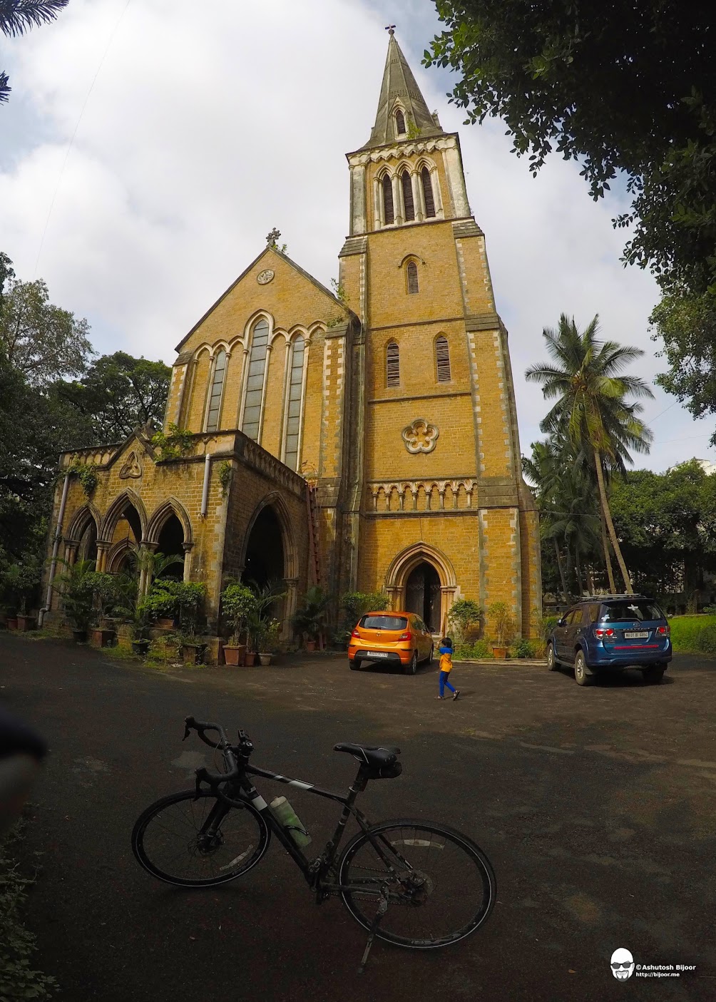
The disaster of 1842 in Afghanistan shook Britain to the very core. Almost a whole army had been destroyed on its march back to British India from Kabul in the narrow passes of Khord Kabul and Jugdulluk. Thousands of men lay dead, their bleached bones later discovered by colleagues in General Pollock’s Army of Retribution. The Afghan Church was constructed to commemorate the tragedy.
For more information on the Afghan Church:
South Coast of Mumbai
The southern end of Mumbai is a forked shape with the longer prong of Colaba to the east, and the shorter prong of Malabar Hill on the west, with the arc of Back bay between them, accentuated by the famous Marine Drive.
The tip of the eastern prong is off limits to the public and is restricted to the armed forces. At the eastern end of the Back bay is Tata Institute of Fundamental Research (TIFR), which is also off limits to the public. I rode to the gate of TIFR and then rode back through Cuffe Parade to reach the World Trade Center.

The Mumbai World Trade Centre was built in 1970 by the Shapoorji Pallonji Group. It consists of two towers, the M. Visvesaraya Industrial Research and Development Centre (MVIRDC) and IDBI. MVIRDC, also known as Centre 1 is 156 meters tall and was the tallest building in South Asia until the 2010 completion of The Imperial towers at Tardeo (252m).
For more information on the World Trade Center:
Vidhan Bhavan
From WTC, I rode into the Nariman Point area and stopped to admire the Vidhan Bhavan - the parliament house of the government of Maharashtra. The building consists of two parts - a circular dome in the front with the 21-storeyed honeycomb-like tower building behind. The circular dome houses the two houses of the bicameral legislature. The 288-member Legislative Assembly has an overall seating capacity of 304 members.

The building was inaugurated on April 19, 1981 by former Prime Minister Mrs. Indira Gandhi, clad in a traditional Maharashtrian nine-yard sari!
For more information on the Vidhan Bhavan:
National Center for the Performing Arts (NCPA)
The National Centre for the Performing Arts (NCPA) is India's premier cultural institution. Inaugurated in 1969, it was the first multi-venue, multi-genre cultural centre in South Asia. This is a venue for several new and innovative works by Indian and international artists from a diverse range of genres including drama, contemporary dance, orchestral concerts, opera, jazz and chamber music.

Built on land reclaimed from the sea, the NCPA campus houses five theatres (including the innovative Tata Theatre, designed by the postmodernist American architect Philip Johnson), as well as galleries, libraries, restaurants, and numerous reception spaces.
For more information on NCPA:
Marine Drive - Promenade & the Queen's Necklace
The Back bay extends from NCPA at the south eastern tip to Malabar Hill at the north western end. The entire 3.6 kilometer stretch of coast is almost a perfect arc and the Marine Drive road hugs the coast all through. At night, when the street lights are lit, it resembles a necklace and hence it is commonly referred to as the Queen's Necklace. A wide promenade lines the coast and it is a favorite haunt for joggers, walkers and cyclists.

For more information about Marine Drive:
Chowpatty Beach
I cycled from the eastern end of Marine Drive to the western end, where Chowpatty beach is located. Chowpatty is really Chau-pati (four channels) and is evidence of the inroad of the tide before the western foreshore was reclaimed (ref). The beach is famous for being the primary site for immersion of the the elephant-headed Lord Ganesha's idols during Ganesh Chaturthi. It is also the original destination for the famous Bhelpuri - a snack that everyone in Mumbai loves!

For more information on Chowpatty:
Malabar Hill
From Chowpatty, the arc of Marine Drive ends and continues on to the prong of Malabar Hill that extends due south, separating the Back bay from the Arabian Sea. Malabar Hill, originally called Walkeshwar once had four Shiva temples that were built in the Shilahara period between the 9th and 12th century, and was the highest point on the Bombay island.

Malabar Hill was forest till the end of the 18th century. The Parsi cemetery in the northern end of the hill was set up in the late 17th century. The first access road to Malabar Point was built in 1828. David said that the jungle had hyenas and jackals and there is even a report of a jackal from the forest spotted in the Bombay high court compound (ref).
For more information on Malabar Hill:
Banganga Tank & Walkeshwar Temple
At the southern end of Malabar Hill is located a fresh water lake called Banganga. This tank is perhaps the oldest and largest surviving Hindu holy destinations (tirthasthana) on the island city, and has been in its present form, from the early 18th century. But its history goes back much further to the Shilahara era between the 9th and 13th centuries AD. What is even more astonishing is the fact that the myths and legends associated with the tank and the adjoining Walkeshwar temple complex emanate from the age-old Skanda Purana and further back from the epic Ramayana, which is believed to have been written about three centuries before the birth of Christ (ref).

For more information on Banganga Lake and Walkeshwar Temple:
West Coast of Mumbai
The west coast starts on the west facing coast of the prong of Malabar Hill. The coast is broken at the Mahim Bay, where the original Bombay island was separated from the Salsette island. The beach-lined Salsette island coast starts from Bandra and curves westward gradually till Versova, with Bandra fort at the southern end and Madh fort at the north just across Versova creek.
Priyadarshani Park
I rode down from Malabar Hill to the west towards Bhulabhai Desai Road, also called Warden Road to the south and Breach Candy to the north. On Warden Road, I stopped at Priyadarshani Park to enjoy the monsoon tides lapping the rocky shore.

In the 1970s, the Government of Maharashtra planned to reclaim 100 acres of land along the west coast of Malabar Hill and to convert it into a commercial district like Nariman Point. Fortunately, this plan was thwarted by a People's Movement that was led by a group of prominent citizens. However in the meantime, there was significant land already reclaimed. This was allotted to the Municipality for a playground, park and sports facilities. Priyadarshani Park was the brainchild of Tara Malkani, who was a State Athletics Champion and the VP of Malabar Hill Citizen Club (ref).
For more information about Priyadarshani Park:
Mahalakshmi Temple

Before the 7 islands of Bombay were unified, the Worli creek separated Malabar Hill from the Worli island. In 1782, William Hornby, then Governor of Bombay, initiated the Hornby Vellard engineering project, which consisted of building a seawall blocking the Worli creek to prevent the low-lying areas of Bombay from being flooded at high tide. This project, finished in 1782, would give rise to the construction of a series of causeways, including the Duncan causeway in 1803 which united Sion, then in the northern part of the Parel island, to Salsette island; the Colaba causeway linking Bombay with Colaba and Little Colaba; and the Mahim causeway in 1845, which united Mahim with Bandra. The final product was the unification of the seven islands into a single landmass (ref).
As the story goes, Lord Hornby entrusted the construction of the wall to Ramji Shivji Prabhu, a Govt. Engineer whose attempts were thwarted by the rough sea waves. One night, the Godess Mahalakshmi appeared in his dreams and instructed him to build a temple on top of the hillock. On construction of the Mahalakshmi Temple on the hillock, the wall was successfully built. (ref)
For more information on Mahalakshmi Temple:
- Mahalakshmi Temple - About Us
- The Hornby Vellard Project
- Mahalakshmi Temple - Maharashtra State Gazzetteers
Haji Ali Dargah

The distinct identity of the bay today, is a mosque built on a small rocky island in the middle of the bay. The Haji Ali Dargah was constructed in memory of a wealthy Muslim merchant, Sayyed Peer Haji Ali Shah Bukhari, who gave up all his worldly possessions before making a pilgrimage to Mecca. On his return to Bombay from the pilgrimage, Haji Ali renounced the world, gave away his wealth and lived on these rocks in the bay.
Soon, his sister, Ma Hajiani, joined him having also renounced the world. They were now revered as holy people, and had a large number of devotees. When they died these devotees built two mausoleums — Haji Ali for the brother, on the rock where he meditated, and Ma Hajiani for his sister at a little distance away on Worli bay (ref).
For more information on Haji Ali:
Worli Sea Face
Riding over the Hornby Vellard along the bay, I crossed over to the erstwhile Worli island to ride along the curved promenade of Worli Sea Face. Before it was combined with the rest of the islands, the Worli island was primarily a fishing village. The only inhabitants of the island were the Kolis; and the most noteworthy feature of the locality was a fine grove of Banyan trees that lined the entire stretch of what is now the Worli Sea Face.
The shade of the Banyan, the medicinal properties of its roots, which are said to cure thirst, sorrow and melancholy, have always ensured it a high place in the estimation of the Hindu; and the respect accorded to the trees by early Hindu immigrants probably led to the name 'Vad-ali' (Banyan Row) being applied to the whole island. The people of later ages, confusing the palatal d ' with r, called the place Var-ali, which is now become Varli or Worli (ref)
For more information about Worli:
Worli Fort
At the end of Worli is the triangular prong that juts out into the sea, and where the Worli Fort is located. Worli Fort was built around 1675 by the British, as security outposts to the main Bombay Fort. It is ensconsed in the densly populated fishing village that remains largely unchanged from its earliest history but for becoming more populated and congested.

The Bandra Worli Sea Link that starts from Worli Sea Face intersects the Worli prong and cuts across the Mahim bay towards Bandra. From Worli Fort, one can get a great view of the sea link and of the bay, with Mahim fort to the right in the bay, and Bandra fort across on the other side of the bay at the other end of the sea link.

More information about Worli Fort:
- Worli Fort, Mahim Fort and Bandra Fort - guarding Mahim Bay
- The Rise of Bombay: A Retrospect by Stephen Meredyth Edwardes
Mahim Fort
From Worli fort, I rode back through the crowded bylane of the fishing village and joined the old Cadell Road that runs along the Mahim bay, passing the Siddhivinayak Temple and Shivaji Park to the end of the erstwhile Mahim island, from where I got on to the Mahim Causeway that connected Mahim island to Salsette (Shashti) island to the north. At the junction of Cadell Road and Mahim Causeway near the shore, and completely overrun by slums is the Mahim Fort.

The only way to see the fort is during low tide, by walking on to the rocky beach and seeing the ramparts of the fort from outside. I had done that on my last visit to the fort, and skipped that stop on today's ride.
More information about Mahim Fort:
- Worli Fort, Mahim Fort and Bandra Fort - guarding Mahim Bay
- The Rise of Bombay: A Retrospect by Stephen Meredyth Edwardes
Bandra Worli Sea Link Promenade
From Mahim Causeway, I turned left on the Bandra Reclamation section of the Western Express Highway that leads up to the Sea Link. The entire stretch of this reclaimed land has been built into a promenade that runs along the coast, and provides great views of the Mahim bay and the sunset.

This spot on the promenade is a new "selfie spot" that must occupy several terabytes of photographs taken by visitors.

At the end of the promenade, the Indian flag is at half mast to respect the decent demise of India's ex Prime Minister and poet, Atal Behari Vajpayee.

Here's a snippet of one apt poem by him:
मौत की उमर क्या है? दो पल भी नहीं,
ज़िन्दगी सिलसिला, आज कल की नहीं।मैं जी भर जिया, मैं मन से मरूँ,
लौटकर आऊँगा, कूच से क्यों डरूँ?
Translation:
What is the age of death? Not even two moments.
Life is a journey, not a day long affair.I have lived life to the fullest, I will die happily.
I will return, why should I fear the end?
Bandra Fort
Bandra Fort or Castella de Aguada located at Land’s End in Bandra. I wanted to get a different perspective of the fort, and so found my way through a narrow street along the shore to a point from where I could see the fort and the sea link both.

The fort was built by the Portuguese in 1640 as a watchtower overlooking Mahim Bay, the Arabian Sea and the southern island of Mahim. The strategic value of the fort was enhanced in 1661 after the Portuguese ceded the seven islands of Bombay that lay to the immediate south of Bandra to the English.
For more information on Bandra Fort:
Return to Home
From Bandra Fort, I rode along the coast, passing Khar Danda and on to the Juhu beach front, where I spend a few minutes enjoying the sea breeze, and then took a brief halt at the Mukteshwar Temple in Juhu for old times' sake for it is close to where I used to live as a child.

I got back home for a late afternoon lunch, famished but satisfied after the nice coastal ride. It was a perfect cloudy day that was not too hot, and with just the right amount of rain to keep me cool!